LST validation station on Lake Constance, Germany
Overview
Large water bodies are the most homogeneous and isothermal ‘land’ cover and, therefore, are ideal for validating satellite-retrieved surface temperatures and for sensor calibration. Lake Water Surface Temperature (LWST) refers to the surface skin temperature of the lake and is most accurately determined from fiducial reference measurements (FRM) with thermal infrared (TIR) field radiometers. Various Land Surface Temperature (LST) and Sea Surface Temperature (SST) products are operationally retrieved from a number of satellite sensors, but have not been validated over a common lake water target, which requires that simultaneous and co-located in-situ Lake Water Surface Temperature (LWST) data are available.
Location
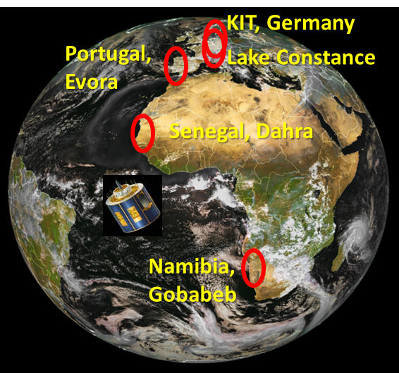
Since 2014 KIT performs radiometric measurements from the car ferry Friedrichshafen, operated by the Bodensee-Schiffsbetriebe GmbH (BSB) on Lake Constance between Friedrichshafen (Germany) and Romanshorn (Switzerland). The Friedrichshafen runs all year around and makes up to 16 crossings per day.
Instrumentation and Measurements
In April 2016 an improved instrument package was installed and since then LWST data from the ferry are nearly continuously available. Measurements are made along the ferry’s track at 100 m sampling distance, thereby allowing detailed analyses and studies of the evolution of LWST over a diurnal cycle. Figure 3 shows validation results for the SST product ‘WST’ retrieved from the Sea and Land Surface Temperature Radiometer (SLSTR) onboard the European satellite Sentinel-3A.
LST validation station in Evora, Portugal
Location
Evora LST validation station is located about 12 km south-west of the town of Evora in the Alentejo region, Portugal. In-situ measurements at Evora started in 2005, but the set-up with the current orientation of the radiometers is in operation since March 2009.
Vegetation
The dominant vegetation types at the station are isolated groups of evergreen oak trees and grassland, which is mainly used for grazing cattle. The cork oak trees have a stable age distribution and a high average age. About three kilometres south and east of the station there are agricultural areas whereas to the West there are plantations of fast growing eucalyptus trees.
Climate
The climate at the station is warm temperate with hot, dry summers, annual temperature averages between 15°C and 16°C and an average annual precipitation of 669 mm. From about May to September the grass is usually desiccated so that the oak trees are the dominant green vegetation. In contrast, November to March are wet months with a rapidly developing vegetation cover: the combined effect is a strong annual amplitude of green vegetation.
LST validation and atmospheric station Namibia, Gobabeb
Overview
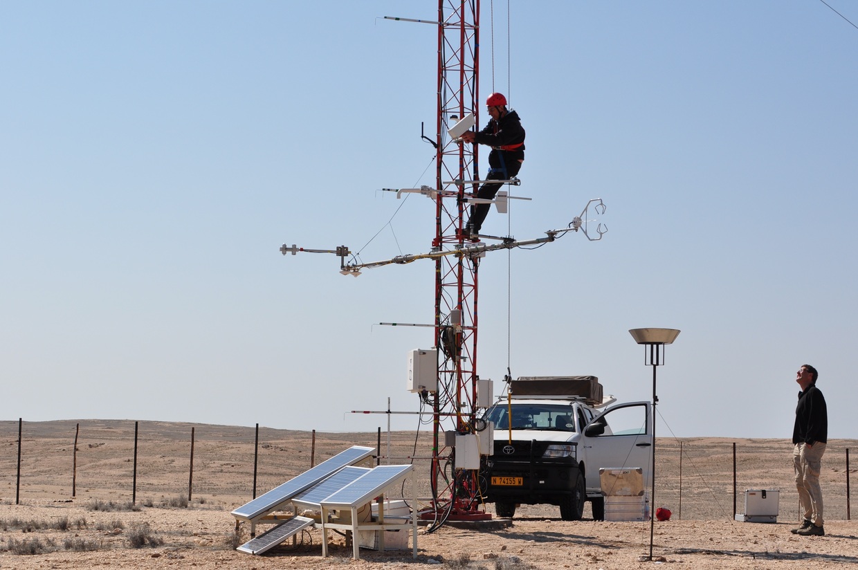
KIT operates two LST validation stations, which are located north-east of Gobabeb Training & Research Centre in the Namib Desert, Namibia. The validation area consists of large gravel plains (several thousand km2), which are covered by a highly homogeneous mixture of gravel, sand and sparse desiccated grass.
Locations
The main LST validation and atmospheric station was set up in December 2007 and lies 2 km north-east of Gobabeb Training & Research Centre in the Namib Desert, Namibia.
The LST validation station 'Gobabeb Plains' was set up in September 2012 and lies about 7 km north-east of Gobabeb Training & Research Centre in the Namib Desert, Namibia.
Climate
Due to the hyper-arid desert climate, the site is spatially and temporally highly stable and, therefore, ideal for long-term validation of satellite products. The long-term average annual temperature at Gobabeb is 21.1°C whereas the average annual precipitation is less than 100 mm and highly variable. Therefore, fog is of special importance for the water balance of the Namib.
Instrumentation and measurements
Continuous in-situ measurements from Gobabeb are available since the beginning of 2008 and the homogeneity of the site was investigated with several field campaigns. The pointing of the radiometers to the assumed surface end-members has not been changed since December 2007.
Further Instrumentation
LST validation station on Farm RMZ, Namibia
Location
‘Rust mijn Ziel’ (RMZ) farm LST validation was located on a plateau in the Kalahari semi-desert about 140 km south-east from Windhuk. In February 2011 the station was relocated to farm 'Heimat', which has quite similar land scape and vegetation consisting mainly of patchy desiccated grass dotted with bushes and isolated camel thorn trees. RMZ farm raises livestock (cattle & sheep) and is also used for hunting game (mainly springbok and Oryx). The farm has a size of about 50 km2 but the land cover (‘Kalahari bush’) and land use in a wide area (thousands of km2) around it is identical.
Climate
The Kalahari is characterised by a hot and arid climate, which exhibits a natural seasonality: there is a small rainy season with little rain (September to November) and a big rainy season (January and March) with possible flooding. Outside the big rainy season the Kalahari bush is dry and the grass is quickly desiccated. In winter the high elevation of the station frequently results in cold temperatures well below freezing point. Due to the station's high elevation (1450 m a.s.l.) the water vapour column between the surface and a satellite is quite small (i.e. the half-height value w.r.t. sea level is 2 km): when not accounted for, this may cause significant error in satellite products.
Instrumentation and measurements
‘Rust mijn Ziel’ (RMZ) farm LST validation station operated between March 2009 and February 2011 and was subsequently moved to the nearby farm 'Heimat'.
LST validation station on Farm Heimat, Namibia
Location
Farm Heimat lies about 100 km south-east from Windhuk and has quite similar land scape and vegetation as RMZ farm, which mainly consists of patchy desiccated grass, bushes and some camel thorn trees. The farm is mainly used to raise livestock (cattle & sheep). The farms has a size of about 50 km2, but the land cover (‘Kalahari bush’) and land use in a wide area (thousands of km2) around the farm is identical. Cattle are carefully managed and moved systematically between fenced off “camps” to avoid overgrazing.
Climate
The Kalahari is characterised by a hot and arid climate, which exhibits a natural seasonality: there is a small rainy season with little rain (September to November) and a big rainy season (January and March) with possible flooding. Outside the big rainy season the Kalahari bush is dry and the grass is quickly desiccated. In winter the high elevation of the station frequently results in cold temperatures well below freezing point. Due to the station's high elevation (1380 m a.s.l.) the water vapour column between the surface and a satellite is quite small (i.e. the half-height value w.r.t. sea level is 2 km): when not accounted for, this may cause significant error in satellite products.
LST validation station in Dahra, Senegal
Location
Dahra LST validation station is located about 7 km north-east of the town of Dahra, Senegal.
Vegetation
The field site is hosted by the Centre de Recherches Zootechniques de Dahra, Institut Senegalais de Recherches Agricoles (ISRA) and is used to validate satellite products in the visible, near-infrared (University of Copenhagen) and the thermal domain (Karlsruhe Institute of Technology). The area around the station is practically unpopulated, covered by seasonal grass (95%) and sparse trees (dominantly acacia trees) and the background soil is sandy and reddish in colour. the entire site is grazed by cattle and sheep and migrating camels from the northern Sahel feed on the leaves of the trees. In some cases the distribution of the bushes and trees follows ancient dunes, which causes stripes of high vegetation - hence the name “tiger bush”.
Climate
Dahra is characterised by the hot-arid, steppe-prairie climate typical of the Sahel region. During the dry season from October to March the climate is especially hot and the grass desiccates rapidly, whereas the trees stay usually green throughout the year. During the wet season (July to October) the atmosphere is generally very humid, cloud-cover is strong and persistent, and the grass grows high (about 1m) and dense. The long-term average annual precipitation is about 370 mm. Due to the distinct dry and wet seasons the validation site exhibits a strong annual vegetation cycle.


