
URCLOCK - URban CLOud patterns, drivers and feedbaCKs
- Contact:
- Funding:
German Research Foundation (DFG)
- Start Date:
2022
- End Date:
2026

Project Summary
Urban land use and human activities in cities modify the regional climate and thus the living conditions in cities. The urban heat island effect, the emission of anthropogenic aerosols, and the increased roughness length of cities shape mesoscale processes in complex ways and can contribute to the enhancement (reduction) of low-level convective (stratiform clouds) in the proximity of urban areas. In view of global climate change and the uncertainties still associated with the role of clouds in the climate system, a complete understanding of all factors impacting clouds is urgently required. The aim of the project is the spatiotemporal quantification of urban cloud patterns and properties, the analysis of their main influences and the estimation of the feedback on the urban radiation budget using satellite observations and numerical modelling over Europe.
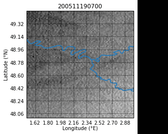
Low-level cloud dissipation over Paris (20-11-2005, SEVIRI MSG satellite data)
Current objectives:
- Diurnal patterns and drivers of urban low-level clouds in Milan based on satellite and ground-based data
This study utilizes data from the SEVIRI (Spinning Enhanced Visible Infra-Red Imager) satellite to study urban low-level patterns. Additionally, data from METAR (Meteorological Aerodrome Report), urban weather stations, and ERA-5 reanalysis is used to investigate both the local and large-scale characteristics of urban cloud dissipation.
- Prediction of urban cloud dissipation using machine learning
This research aims at the automatic detection of urban cloud dissipation. A convolutional neural network (CNN) is trained based on SEVIRI and MODIS satellite data to be applied on European urban areas.
- Urban low-cloud dissipation using numerical modelling
Multiple ICON-LAM simulations are performed by switching aerosol processes (ART module), dynamical and thermodynamic processes (ICON) and the urban canopy model TERRA URB on and off. In this way, the model response to each impact on cloud development can be determined.
- High-resolution satellite-based cloud detection
In this study, SEVIRI satellite observations are used to develop and validate two high-resolution cloud-masking approaches for the region of Paris to show and improve applicability for analyses of urban effects on clouds.
Reference:
Fuchs, J., Andersen, H., Cermak, J., Pauli, E., and Roebeling, R.: High-resolution satellite-based cloud detection for the analysis of land surface effects on boundary layer clouds, Atmos. Meas. Tech., 15, 4257–4270, https://doi.org/10.5194/amt-15-4257-2022, 2022.